Set in the west of the city centre, Leeds Innovation Arc is a world-class hub for research and innovation. The Innovation Arc brings together the City's anchor institutions -Leeds Teaching Hospitals NHS Trust, University of Leeds, Leeds Beckett University, Leeds Arts University, Leeds City Council - with one of the UK's strongest and most dynamic networks of private sector businesses.
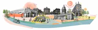
The area is home to some of Leeds most important and recognisable buildings and heritage assets, its civic core and a wealth of cultural facilities. It is the access point to the city from the surrounding residential areas to the west and north and has the potential to connect directly with regeneration underway at the South Bank.
Planit, working in collaboration with Deloitte (and informed by a separate economic study by Metro Dynamics) produced the Leeds Innovation Arc Supplementary Planning Document (SPD) on behalf of Leeds City Council.
Urban Design, Education
Complete
Civic Engineers, Deloitte
Leeds City Council
150ha
2018 - 2023
West Yorkshire
Watch studio story
In-depth spatial analysis
Planit was initially commissioned to undertake an in-depth spatial analysis of Leeds City Centre West which developed a vision and accompanying implementation and phasing strategy to promote Leeds City Centre West as a hotspot for innovation. The Innovation Arc became a key outcome of the spatial analysis study which was then used to drive interest and receive backing to turn this work into a SPD adopted by Leeds City Council.
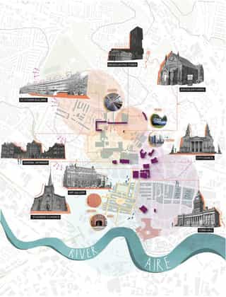
The SPD area, totalling circa 150 hectares, focuses on the area west of the city centre. The area encompasses key land holdings and districts including the University of Leeds, Leeds Beckett University, Leeds General Infirmary and the primary central business district around Wellington Place and Park Square.
The ingredients for innovation
Whilst the ingredients of a successful innovation hub are all present, the area does not currently maximise its potential. The area's best assets are disconnected and lack a common identity and sense of purpose. Prior to the Innovation Arc there was no overarching framework to foster collaboration and deliver regeneration outcomes across the area.
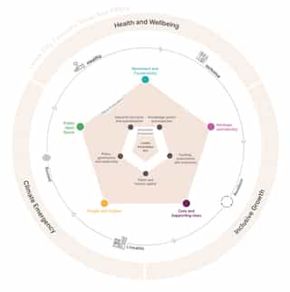
The SPD defines what innovation means and will look like for Leeds and how it should translate spatially across the area. The guidance sets out appropriate types of development in the most suitable locations and how they are delivered in line with the vision and its objectives. The strategies; movement and connectivity; public open space; heritage and identity; people and culture and; core and supporting uses; ensure the guiding principles of innovation meet those of placemaking collectively in any new development or public projects coming forward.
The SPD was adopted in Summer 2023.
Turning policy into tangible impacts
Leeds' has three priorities, to deliver inclusive growth, health and wellbeing and responding to climate change, these are at the forefront of what the Innovation Arc seeks to achieve. Planit led the spatial analysis of this part of Leeds city centre, exploring how and where innovation could thrive and be supported, and where spatial interventions would have the potential to deliver the most tangible positive impacts.
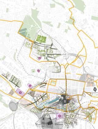
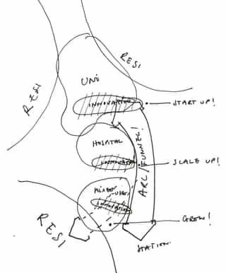
The Arc is formed of a series of innovation neighbourhoods, formed around the natural anchors of Leeds' three largest universities, Leeds General Infirmary and a cluster of private sector employment around Wellington Place.
The neighbourhoods will be rooted in Leeds' heritage, revitalising and securing the long-term positive reuse of some of the city's most important and recognisable historic buildings. The neighbourhoods will provide new innovation space to support start-ups, growing businesses and major employers along with shared spaces, internal and external, where people can meet and exchange ideas. There will be an increase in new homes in and around the Arc. An increase in population, supporting retail and 12 existing cultural destinations will enliven the area. New public realm improvements, with the potential for two new city parks will create large areas of new green spaces.
These neighbourhoods will be integrated across the Innovation Arc, connecting all of the university campuses southwards through to the redeveloped Leeds Station and the South Bank. They will repair and enhance routes for pedestrians and cyclists, with the potential for new, large-scale cycle infrastructure across the area. The area will capitalise on the future potential mass-transit system to reduce travel times to and from Leeds Central Station, strengthen the existing public transport network and bring sustainable modes of travel into the heart of the Innovation Arc. In turn, increasing chances for
An Innovation Ecosystem
Innovation thrives in the overlap; the friction created when neighbourhoods, uses and their activities collide, resulting in new ideas, collaborations and exploratory outcomes.
The friction of uncoventional uses and knowledge coming together sparks creativity and fosters experimentation.
Setting up and harnessing this friction and overlap of uses, assets and knowledge within cities, can allow innovation to manifest at those intersections within both new and existing neighbourhoods.
Planit have developed a methodology to formulate, measure and test places and spaces for their potential to support Leeds' innovation ecosystem. This methodology was applied to each innovation neighbourhood and underpinned the design of the Innovation Arc and the subsequent development guidance and opportunities outlined in the SPD.
The Arc
Through the analysis of the spatial development context and the concept of a distinctive spatial Arc has emerged.
The top of the Arc is formed by the university and the long minear mass of the EC Stoner building, the tail end of the Arc feathers out reaching south west towards the River Aire whilst touching the edge of the station in the east. The Arc connects the three Innovation neighbourhoods.
- Land Uses - Start with the existing land uses.
- Local Centres - Overlay the existing local centres and 5 minute walking distances. Notice how the local centres are often located at the interfaces of differing land uses.
- Points of Collision and Critical Mass - Look for the overlaps and areas of collision; these suggest points of gravity and potential critical mass. Innovation thrives in the overlap.
- Three Hotspots - The overlaps and collision points suggest three areas of interest; three potential innovation neighbourhoods.
- Differentiate Identity - Each neighbourhood has its own character and focus, with each having the potential to offer a different innovation function.
- Connect to form the Arc - The neighbourhoods are connected to form an 'Arc of Innovation'. The Arc is connected into the wider city, the train station and the surrounding communities.