Working for Sheffield City Council, the framework has informed the emerging Sheffield Local Plan - forming a unique approach to holistic city making, whilst considering the importance of liveable neighbourhoods as units of change.
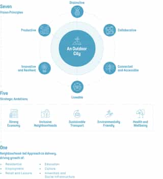
It supports the city on its path to Zero carbon, delivering on Sheffield City Council’s vision of the Outdoor City. It has also enabled and catalysed a liveable city comprising 20,000 hew homes – employing a bespoke and innovative approach to calculating capacity.
The work comprises three distinct workstreams: the Sheffield City Centre Strategic Vision; City Centre Strategic Neighbourhood Guidance and supporting Delivery Strategy and an Investment Prospectus. This suite of documents will act as a basis upon which SCC will begin to realise its ambitions for creating a Sheffield City Centre that is fit for the future. As well as providing the platform to deliver a significant number of new homes as part of the curation of new distinctive neighbourhoods in the City Centre.
Urban Design, Residential
Complete
Deloitte
Sheffield City Council
400ha
2019 - 2020
Sheffield
Watch studio story

The plan provides the necessary strategic thinking at the city-scale. It builds on a clear vision of the Outdoor City and considers physical, environmental, economic and social considerations holistically. In turn, it exploits interdependent connections across sectors to deliver cross cutting impacts and policy synergy. It then delivers this at the neighbourhood level – the most important unit of change within any city.
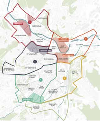
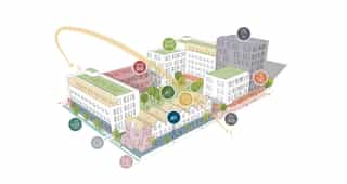
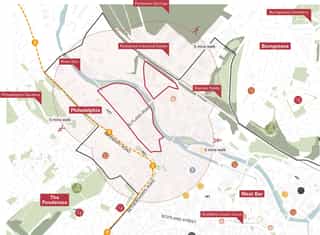
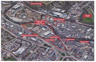
The purpose of the Neighbourhood Frameworks was to provide an overarching framework to guide the future development of the 23 sub-areas of Sheffield City Centre, and define a masterplan and outline development principles for 5 Priority Locations in the City Centre (Neepsend, Furnace Hill, Moorfoot, Wicker Riverside and Castlegate) to guide future development in these areas.
The research undertaken for this piece of work has considered adopted National and Local Plan policy and guidance, as part of wider evidence gathering. Documentation has been reviewed and interpreted to respond to the City Centre Strategic Vision and future growth. This work, including guidance, was incorporated into the Draft Sheffield Local Plan, in the form of specific policies.
The Neighbourhood Frameworks develop the concept of creating new distinctive, mixed use neighbourhoods underpinned by a masterplan approach to development as advocated in the City Centre Strategic Vision.
A liveable neighbourhood approach considers the surrounding context, history of the area, location and role within the wider city context, and lays the foundations for the strategic vision for each neighbourhood, promoting liveable and walkable communities within Sheffield City Centre.

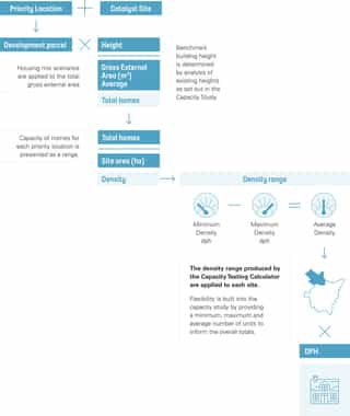
The framework provides high level place-making principles and directly links to the development capacity of each priority location. Further detail for 3 smaller areas within the Priority Locations set out the type of development that will drive growth and potential delivery mechanisms to guide development and investment decisions in these catalytic sites. The work considered increases in height and density across the city, in accordance with high-quality design principles.
 Expand
 Expand
 Expand
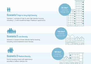
The Neighbourhood Framework forms part of a suite of documents for the City Centre, which informed the development of the Sheffield Local Plan.
The documents have helped position Sheffield as one of the early ‘Transformational Projects’ announced in the Levelling Up White Paper. This has increased the economic profile of the city and has been pivotal in attracting further public/private investment - culminating in £3m in funding from Homes England and £1.5m from Sheffield City Region.