What is Impact Assessment?
Impact assessments, such as LVIAs and TVIAs, are formal studies used to assess the likely environmental and visual impacts of a proposed development. They are often required as part of planning applications - and useful design evaluation tools - especially for significant or sensitive developments.
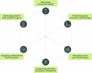
In essence, they evaluate what makes a current place, how a proposed development might affect the character and composition of this place, and how people will experience change overtime.
Why is Impact Assessment important?
Impact assessment plays a key role in the development process in 3 main areas...
- It directly links architectural, urban design and landscape proposals to the wider planning framework.
- Recognised within national policy, locally adopted policies and design codes.
- Ensures new development is context-sensitive, visually appropriate, and publicly understandable, supporting better outcomes for developers, planners, and communities.
Impact assessments can bring added value to development projects by...
What is the value of Planits approach to Impact Assessment?
- Over 20 years' experience delivering impact assessments for large, medium, and small-scale projects in the UK.
- Use of robust methodology process in line with the Landscape Institute's published Guidelines for Landscape and Visual Impact (GLVIA).
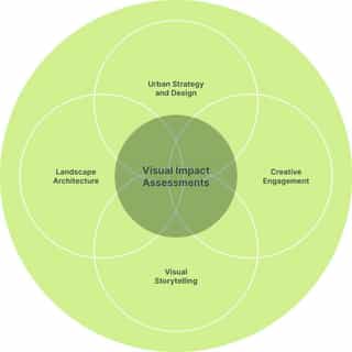
- An interdisciplinary service that offers connective thinking for cohesive design solutions, and an 'end-to-end' service across the development process.
- Unique ability to draw upon deep cross-sector knowledge and experiences with planning teams across the UK, married with our world-class visualisers to provide informed, accurate and speedy impact assessment services.
Case Study Stockport 8
- Major regeneration project in Town Centre West area of Stockport, delivering a new walkable neighbourhood with up to 1,300 homes.
- Planit's Impact Assessment service played a key role in shaping the development, steering a contemporary yet contextually responsive high-density mixed-use scheme, in close to proximity to listed heritage assets.
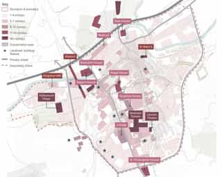
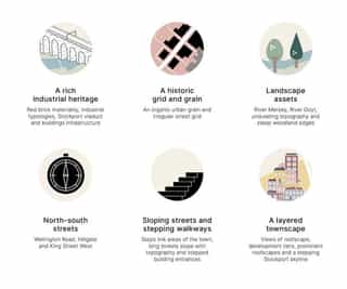
- It required an extensive townscape and visual analysis from the outset to understand what makes the place of Stockport - identifying key characteristics and tailored design advice to enable a dense and landmark development in a sensitive context.
How did Impact Assessment play a key role in the design process?
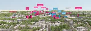
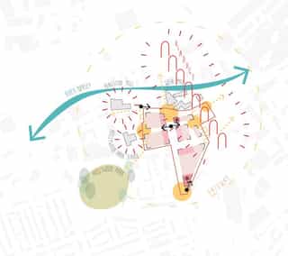
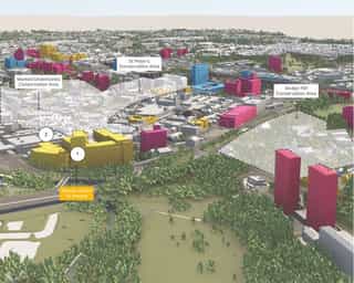
Identified key viewpoints, alongside potentially sensitive townscape receptors, in order to understand early potential impacts that needed to be addressed in the masterplan
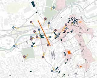
Identification of key routes, conservation areas, public spaces, heritage assets, etc...
- Understanding of relationship between Stockport 8 site and surrounding townscape.
- Mapping location of sensitive townscape receptors and key heritage assets, including the town centre conservation areas.
- Enabling an identification of potential townscape and visual sensitive areas early in the design process.
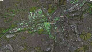
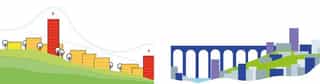
ZVI mapping of viewpoints alongside potentially sensitive townscape receptors...
- Demonstrating theoretical 'visual envelope' of the proposed development.
- Identifying potential areas where people may experience change as a result of the proposed development.
- Used to inform the viewpoints plan to avoid potential harm to visually sensitive receptors.
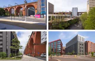
Townscape analysis to identify unique features and relationship between tall buildings...
- Use of VU.City to visualise the unique Stockport town centre skyline.
- Stockport skyline formed along Mersey Valley, responding to undulating topography through layered townscape, stepping with changes in levels.
- Enabled understanding of unique features, relating to vernacular, roofscape, fenestration, etc.
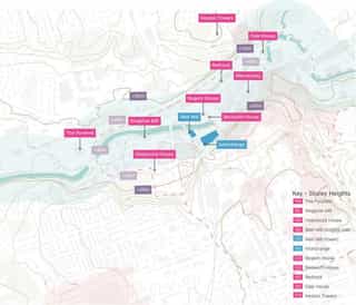
Early engagement with Stockport Council to agree location of selected viewpoints...
- Views based on defined conservation area appraisals, and established townscape / visual sensitivities.
- Early townscape and ZVI analysis created clear correlation to selected views, allowing for better engagement with the Council.
- Allowed for early testing of the proposed development massing model from the agreed viewpoints.
Previous steps enabled early testing of massing to communicate potential impact of proposals...
- Use of VU.City 3D model of development massing to demonstrate potential changes to agreed viewpoints.
- Subsequently began to inform potential design mitigation strategies from outset, responding to key townscape forms, such as the railway viaduct.
- Early established feedback included a contextual roofscape response where built elements rose above the viaducts, i.e. pitched / sawtooth, contrasting colour, visual interest.
A leading voice throughout the early design process to inform the site’s design and mitigation strategies
Collaboration with architectural team to develop scheme iterations and inform design...
- Iterative use of VU.City model and urban design strategies to test the scheme's contextual response to townscape and heritage, up until design freeze stage.
Process allowed for exploration of...
- Appropriate location of taller 'gateway' buildings;
- Acceptable range of height datums;
- Building responses to topography;
- Materiality to ensure elevations interact with viaduct arches to create visual contrast, and remain identifiable post-development; and
- Roofscapes to create visually prominent forms that rise above viaducts and relate back to the Stockport townscape.
Enabled formation of embedded mitigation measures into the design proposals...
- TVIA analysis and design strategies, integrated from the outset of the process, meant these strategies formed a key part of the embedded mitigation.
- Ensured a contextual and sensitive response to the townscape's characteristics, whilst promoting place quality and visual interest to enhance the industrial heritage of Stockport.
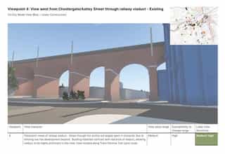
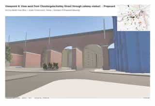
Cross-collaboration with Virtual Planit for production of high-quality verified views, allowing for feedback on detailed design matters, and ultimately ensuring a robust final TVIA delivery for the client.
Collaboration with our in-house visualisation team to produce accurate representations...
- Unique cross-collaboration with Virtual Planit enabled the development of verified photomontages to complete the TVIA assessment process - where the early analysis benefitted the final assessment, through contextually designed embedded mitigation measures that integrated the scheme into its surroundings.
- The verified views further influenced the colours of the special roofscape elements on detailed Phase 1, which were altered to ensure they best complemented and fitted in with surrounding heritage features.
Looking for an Impact Assessment?
Our integrated team of designers, assessors, and visualisers can offer the following expertise across Planit's Impact Assessment service...
- Full LVIA / TVIA reports, including Environmental Statement (ES) chapters or standalone appraisals
- Impact assessment analysis and design input early in the masterplanning process
- Accurately presented verified views across all AVR ranges
- Leading innovation and technology through verified kinetic views
To find out more about this project, or to discuss our Impact Assessment, Verified Views and Visualisation services, please contact...
- Adam Fall - Urban Designer and LVIA / TVIA Assessor (af@planit-ie.com)
- John Willerton - Principal Urban Designer (jw@planit-ie.com)
- Rich Line - Director of Virtual Planit (richard@virtual-planit.com)
Related Thoughts
Queen Elizabeth Olympic Park Climate Emergency Design Guidance
Queen Elizabeth Olympic Park Climate Emergency Design Guidance
Planit’s Urban Design team create a new vision for Hull
Planit’s Urban Design team create a new vision for Hull

Virtual Planit unveils a brand new look!